Geographically part of the Dinaric Alps, a mountain chain crossing over eight South European countries, Albania boasts more than a dozen national parks which have been included in the Dinaric Arc Parks, a project initiated in 2012 by Switzerland-based World Wide Fund for Nature (WWF), gathering nature and national parks of South-East Europe.
The Dinaric Arc is a region of South-Eastern Europe that covers some 100. 000 km2 and more than 6.000 km of coastline, stretching over the entire area oriented towards the Adriatic Sea from Trieste (Italy) to Tirana (Albania). WWF started the project Dinaric Arc Parks in early 2012, with the aim to create an association of nature parks in the territory of Albania, Bosnia and Herzegovina, Croatia, Kosovo, Macedonia, Montenegro, Serbia and Slovenia.
The goal of the Dinaric Arc Parks project is to maintain and strengthen political will for dialogue and collaboration between the countries of that region as well as to promote this beautiful but hidden treasure of nature.
“With its natural and cultural values, the Dinaric Arc stands even with the Carpathians, Alps or any other known eco-region in the world. This is why we created Parks Dinarides brand, with the slogan the World Undiscovered,” says the Dinaric Arc Parks on its website.
The list of 15 Albanian national parks part of the Dinaric Arc includes famous tourist attractions from northern Theth and Lura to southern Albanian Llogara, and Karaburun-Sazan parks.
Below are some of the most popular national parks featured in the Dinaric Arc project:
Qaf뭠Shtama
The Qaf뮓htama national park is located 25 km northeast of Kruja. The spectacular views and high peaks of this location are truly breathtaking. It comprises an area of 2,000 hectares. The road that leads to the entrance of the park goes through the narrow Vaja Canyon, about 600-700 metres deep, formed by the Droja River that flows at its bottom. The legend goes that after the occupation of Kruja by the Turks, ninety young virgins from the town threw themselves down to the bottom of the canyon in order not to fall into the Turks’ hands. The vegetation in the Qaf뮓htama park consists mainly of pine forests, which make it a place with good climatic conditions believed to help relieve lung conditions. In the Qaf뮓htama park, there is also the famous Burimi i N쯫s Mbret쳥sh련Queen Mother’s Spring), which flows with crystal clear water noted for its health benefits thought to have drinking water of curative properties. Qaf뮓htama is suitable for nature tourism with activities such as hiking, camping, etc.
North of the pass road is the major part of the park, mostly undeveloped land with mountain forests, where pines, beech and oaks dominate. The black pines are one of the most important resources in Albania. The forest retreat is known for brown bears, wolves, foxes and various birds.
Llogara
Llogora has been a national park in Albania since 1966 under a decision by the Albanian government. The park covers an area of 1,010 hectares and protects the forests on the north side of the Llogara Pass between a height from 470 to 2,018 m above sea level. The park is famous for its black pine trees, Bosnian Pines, Bulgarian fir, and ash trees. Air currents around the area have caused trees to bend in many interesting shapes, like the Flag’s pine (Pisha e Flamurit).
Along the road, there are several restaurants, hotels, and a small wooden cabin complex. The area of the park and the surrounding mountains is used mainly for hiking and tracking tours. A paragliding site serving annually as an international competition venue is located south of Llogara. Along the curvy road are also located several local vendors of honey and mountain tea. Caesar’s Pass (Qafa e Cezarit) named after Julius Caesar who set foot in the area in pursuit of Pompey is also located near Llogara Pass.
Drenova Fir
The park is situated 10 kilometres from Kor衬 southeastern Albania, on the side of the Morava Mountain and has many attractive points including Bozdoveci, Guri i Capit, Cardhaku, etc. The Drenova National Park Forest is known as “Bredhi i Drenoves” (Fir of Drenova). It is also rich in other beech and black pine trees. The forest slopes are covered with hazelnut trees. The Park has a rich fauna and includes the famous Bozdoveci Bear, a monument of nature. It has an area of 1,380 hectares, of which 750 hectares are covered by forests, 240 hectares of pastures, and the rest is rough country land.
The area is largely frequented by visitors. The numerous natural springs with all-year drinking water, such as those of Sh쮠Gjergj, Plaka, Pllica, add to the attractiveness of the park.
Karaburun – Sazan
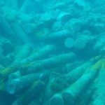
Proclaimed in 2010, the Karaburun-Sazan National Marine is the only national marine park of Albania. The park covers a marine area stretching 1.9 km along the coastlines of Karaburun Peninsula and Sazan Island near the Bay of Vlora. The marine park is 16 kilometres long with a width varying from 3 to 4.5 kilometres, and covering 12,428 ha of surface in total. Karaburun Peninsula itself is a Managed Nature Reserve while the Sazan Island is a military zone in Albania.
The marine park features ruins of sunken Greek, Roman and World War II ships, rich underwater fauna, steep cliffs and giant caves, ancient inscriptions of sailors on shore, secluded beaches, and breathtaking views of the coastline.
This park is considered the rich variety of underwater landscapes, habitats and species of marine fauna and flora as for accommodation, food and breeding for a number of species of national, regional and global importance. Distinctive features of its biodiversity are underwater meadows of Posidonia. Also, it is suitable for the growth of many plant and animal underwater organisms, starting with marine algae, sponges, mollusks, crustaceans, red coral, reptiles, mammals. Benefits from the creation of marine national park consists, besides the protection of the marine natural environment, biodiversity, underwater landscape, the caves, canyons, etc., but also to promote underwater tourism, including cultural and historical values inside the underwater surface him.
Divjak뮋aravasta
The Karavasta Lagoon is the largest lagoon in Albania and one of the largest in the Mediterranean Sea. The lagoon is situated in the west of Albania and the largest town found near the lagoon is Lushnj뮠The lagoon is cut off from the Adriatic Sea by a long sandy bar. It has many pine trees and small sandy islands and is famous for the rare Dalmatian Pelican which nests there: In fact 5% of the world’s population of this type of pelican is found in this lagoon.
The Karavasta Lagoon is within the List of Ramsar wetlands of international importance and part of the Divjake-Karavasta National Park.
The Divjaka-Karavasta National Park is the largest non-coastal complex in Albania with an area of 22,230.2 hectares, made of four lagoons with a total of approximately 5,000 hectares, of sand dunes and a river delta.
There is a Mediterranian Pine Forest near the Karavasta lagoon, and it contains one of the most interesting faunas of the country.
The islands in the lagoon are one of the most important features of the area for the conservation of birds. Although in the past, the Dalmatian pelicans have nested in other parts of the lagoon, they now only nest on these islands, owning to disturbance elsewhere.
Dajti
Mount Dajti National Park is situated 26 km east of the capital and 50 km east of Tirana International Airport Mother Teresa. The park has a surface area of 3,300 hectares, is highly frequented by day and considered the ‘Natural Balcony of Tirana’.
Dajti Mountain together with Priska Mountain (1353m) to the south and Brari Mountain to the North consists of the national park which has an exact coverage area of 29,216.9 hectares. In addition to the forests and beautiful mountain landscapes with many wild flowers, numerous mammals are protected as well. The wild boar, the Eurasian wolf, the red fox, the European hare, the brown bears and wildcats can be found in the park. In the lower part of the mountains, the vegetation is scrub determined with much heath, myrtle and fragaria. Oak dominates at around the 1,000 metres altitude zone following with beech forests with some conifers.
Dajti Mountain can be reached through a narrow asphalted mountain road onto an area known as Fusha e Dajtit of through cable-car. Famous as a summer camp destination under communism, Mount Dajti now offers a lot of recreational opportunities. Since 2005, hikers and visitors to the mountain can use an Austrian built gondola lift from the eastern outskirts of Tirana to Fusha e Dajtit (Plain of Dajti) at 1050 meters altitude. Lately, traces of prehistoric settlements and fortifications from later periods have been discovered in the area.
Lura
The Lura national park is situated on the eastern slopes of Lura Mountain. The national park covers an area of around 1280 ha. The town of Peshkopi is about 25 kilometres east of the National Park while villages such as Fush뮌ur롡nd Sina e Ep쳭e are even closer to the National Park. The National Park is home to many rare animals such as those mentioned above. But once again the real attractions are its twelve lakes which attract many visitors. With a surface of 1.280 hectares, the park is situated in the eastern side of the mountain massive of “Kunora e Lures”. Its twelve icy lakes offer picturesque and attractive environments at an altitude of 1.350-1.720 m. Among the many lakes the one that stand out are the 32-hectare Big Lake, the Lake of Pines, the Black Lake and the Lake of Flowers. However, after the fall of Communism, the area suffered massive deforestation from illegal logging, and forest fires that have severely affected ecosystems around the many glacial lakes.
In the southern part of the park there is a meadow called Field of Mares which offers a relaxing view, since its vegetation is miscellaneous with multi-color flowers and full of coniferous trees. This park offers various possibilities for developing eco-tourism, winter sports, equitation, horse riding etc. The glacial complex of Lura lakes are one of the most beautiful pearls of Albanian nature. The glacial lakes of Lura have a general surface of 100 ha. They are located in the northeastern part of the country in the district of Dibra. In winter, these lakes freeze, taking the view of natural skiing lanes. The lake of Flowers is really astonishing with the big white water lilies in summer, leaving the impression of a big garden created by the hand of a mastermind.
Thethi
With a surface of 2630 ha: from which 1680 ha forest along the sea-line, Theth is a national park, managed by the Directorate of Forestry Service, district of Shkodra, northern Albania.
The “National Park of Theth” lies into the center of the Albanians Alps, between the block “Bjeshket e N쮵na” on the west, and the block of Jezerca on the east. Thethi is a tourist – alpine region and is the most important one north of the country. It is only 70 km away from the city of Shkodra and part of the commune Shal롷ithin the region of Dukagjin. Some of the most astonishing parts of this national park include the peak of Radoines (2570m), Arapit (2217m), Papluk쳠(2569m), Alis련2471m) etc. Hanging 750-800 meters below within the valley stretches the pictorial village of Theth.
The valley of Theth has recently become a famous tourist attraction among foreign tourists. Right into the heart of the northern Alps, between the historic rocky mountains, amazingly green panoramas and the numerous crystal fountains, this valley lies 900 meters above the sea level.
Valbona Valley
With an area of 8,000 hectares the Valbona Valley national park is the gem of Albanian Alps – Accursed Mountains. Valbona is the name of the river which flows through the Valbona Valley and a village located in the Tropoja District of northern Albania. The Valbona Valley, bordering Kosovo to the northeast and Montenegro to the northwest, in combination with the adjacent Theth district to the west, encompasses a region known as “The Highlands”. The Valbona Valley lies between the rugged and remote and breathtaking mountain peaks and makes a festival of colors and contrasts. Its biodiversity makes it very important as a tourist attraction.
Valbona village is the focal point of the Valbona National Park. Its configuration, hydrology, forests, flowers, characteristic dwellings and the hospitality of its people make this park an ideal place to visit and invigorate. Rocky and steeply high peaks, such as Jezerce, Iron, Kollata (Podi of Kollat쳩, and Pecmarr쳠attract trackers and alpinists. Agricultural and livestock products or the Valbona Valley National Park and area are completely natural, and entirely organic. Food is generally fresh and homemade, but it is also sometimes processed and canned by the inhabitants of the tiny and remote villages. Stunning nature, clean air, high and characteristic mountain peaks, lakes, numerous water resources, forests, mountains, flora and fauna of Valbona Valley National Park provide conditions for true eco-tourism experiences.
Mount Tomor
Mount Tomor is a large mountain in southern Albania. Its highest peak, called ȵka e Partizanit, reaches a height of 2,416 m and reaches upward to a height of 1,200m. It is located east of the towns of Berat and Poli袮 and the river Osum not far from the Canyon of Osum river.
Tomor is of great importance to the local people where a Bektashi religious temple can be found, and offering them many facilities such as skiing. For its importance and beauty, a 4,000- hectare area in Tomorr has been declared a national park.
Just east of Berat lies this scenic mountainous gem. Resembling a natural castle framed by lofty peaks, it is snow-covered in the winter, and holds tremendous religious significance for the Abaz Aliu tribe which lives nearby. The Bektashi believers call this area home, and organizes a large religious festival every August.
Albanian folklore tells how Tomor came to be. The people believed that Tomor was a giant that wanted to fight another giant named Shpirag for a young woman. The two giants killed each other and when hearing the young woman cried and drowned in her own tears thus creating the river of Osum.
Butrint
The archaeological site of Butrint is located within the Butrint national park. The importance of Butrint to Albania’s cultural heritage was first recognized in 1948 when it became a “site of historical importance.”
Butrint, ancient Buthrotum, a port from Hellenistic to Ottoman times, since 1992 is a UNESCO World Heritage Site in south-west Albania, a status that identifies cultural and natural sites of outstanding universal value. Situated on the Straits of Corfu, and surrounded by a picturesque lagoon, it is one of the most remarkable archaeological sites in the Adriatic Sea region.
Following twelve years of archaeological excavations and major investment in site management, the site and its museum make it an exceptionally attractive place to visit. A short ferry or hydrofoil trip from Corfu will bring you to the Albanian port of Saranda, from where you can reach Butrint, 20 km to south, by either bus or taxi.
The National Park was established in 2000 affording Butrint full protection within Albanian Law. The original 2,600 hectares of the park boundaries were in 2005 expanded to 8,591 hectares.
Prespa
The Prespa national park has a surface of about 27,750 hectares and is situated at the cross border of Albania, Greece and Macedonia. It consists of both lakes Big Prespa and Small Prespa as well their reservoirs of water. This area is very rich in cultural values. Worth mentioning is the eremitic churches of Byzantine Age and the cave of Treni, located in the lake of Small Prespa. Here are discovered settlements of the early Age of Bronze, where the castle of Trajan is among the largest prehistoric place of this district, build up in the 8th century BC and the church of Saint Mary built up in the island of Maligrad in 14th century. This region is considered of significant echo-tourism potential. The Lake of Big Prespa and the Lake of Small Prespa are part of the Balkan Park of Prespa. There is potential for development of echo-tourism, recreation, sport fishing, gathering and trading of medicinal plants, family tourism, bird watching, blue tourism, aquatic sports etc.
Prespa is surrounded by high mountains. Its banks are fragmented and there are several small islands. The lake is fed primarily by underground streams and some tributaries. The drain is deeper underground to Lake Ohrid.
The lake is very rich in fish and habitat for many rare species such as pelican and the Dalmatian Pelican.
The Prespa wetlands are particularly sensitive in terms of the Ramsar Convention. The Great Lake Prespa is the center of the Prespa National Park, which was founded by the three littoral states jointly and one of the largest European’s nature reserves. (discoverdinarides.com)